Mariposa County
Mariposa County lies north of Fresno and east of Merced in the foothills of the Sierra Nevada Mountains and is the gateway to Yosemite National Park. Tourism plays a large part in the county economy. There are 1,463 square miles in the county and its county seat is Mariposa. The major State Routes through the county are 41, 49, 120, and 140.
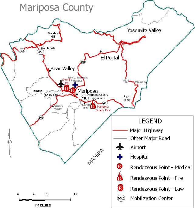
Mercy Medical Transport provides service, in a non-exclusive area, to the citizens of Mariposa County. Air ambulance service is provided by PHI Air Medical and AirMethods. The local hospital is John C. Fremont Hospital.
Dispatch
CalFire
5366 Highway 49 N
Mariposa, CA 95338
209-966-3622
Fire Departments
Mariposa County Fire Department
P.O. Box 162
Mariposa, CA 95338
209-966-4330
Mariposa Public Utilities District Fire Department
P.O. Box 494
Mariposa, CA 95338
209-966-2515
Ambulance Provider
Mercy Medical Transport
P.O. Box 5004
Mariposa, CA 95338
209-966-5762
Air Ambulance
PHI Air Medical
801-D Airport
Modesto CA 95354
1-888-435-9744
http://www.phicares.com/states/california/index.shtml
Air Methods
1329 Spanos Court
Modesto, CA 95355
209-572-7199
SkyLife of Central California
P.O. Box 4
Clovis, CA 93613
559-346-1025
Hospital
John C. Fremont Hospital
5189 Hospital Road
Mariposa, CA 95338
209-966-3631
Medical Rendezvous Point
Health Department
4988 11th Street, Mariposa
Law Rendezvous Point
Sheriff's Office
5099 Old Highway North, Mariposa
Fire Rendezvous Point(s)
County Fire
Hwy 49, Mormon Bar
Mobilization Center
Fairgrounds
Highway 49 and Fairground Road, Mormon Bar
General Information
Population: 17,991
Square Miles: 1,462.9 - 24.4% of Square Miles in Region
